-
Courses
Courses
Choosing a course is one of the most important decisions you'll ever make! View our courses and see what our students and lecturers have to say about the courses you are interested in at the links below.
-
University Life
University Life
Each year more than 4,000 choose University of Galway as their University of choice. Find out what life at University of Galway is all about here.
-
About University of Galway
About University of Galway
Since 1845, University of Galway has been sharing the highest quality teaching and research with Ireland and the world. Find out what makes our University so special – from our distinguished history to the latest news and campus developments.
-
Colleges & Schools
Colleges & Schools
University of Galway has earned international recognition as a research-led university with a commitment to top quality teaching across a range of key areas of expertise.
-
Research & Innovation
Research & Innovation
University of Galway’s vibrant research community take on some of the most pressing challenges of our times.
-
Business & Industry
Guiding Breakthrough Research at University of Galway
We explore and facilitate commercial opportunities for the research community at University of Galway, as well as facilitating industry partnership.
-
Alumni & Friends
Alumni & Friends
There are 128,000 University of Galway alumni worldwide. Stay connected to your alumni community! Join our social networks and update your details online.
-
Community Engagement
Community Engagement
At University of Galway, we believe that the best learning takes place when you apply what you learn in a real world context. That's why many of our courses include work placements or community projects.


April Mapping Seaweed Tides from Space
Mapping Seaweed Tides from Space
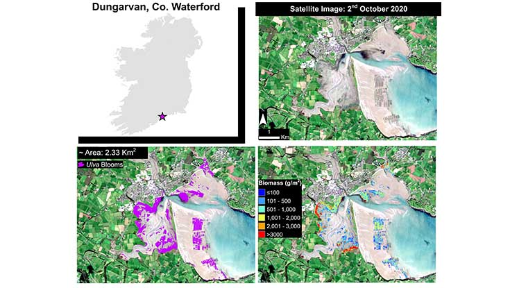
Satellite scene of Dungarvan Bay in Co Waterford showing the Ulva biomass distribution. Photo: Sentinel 2 image from European Space Agency.
Apr
27
2021
Posted: 09:09 IST
A study led by Dr Liam Morrison from the Ryan Institute in collaboration with Dr Sita Karki from ICHEC at NUI Galway, have used macroalgal blooms for the assessment of the ecological status of coastal and estuarine areas in Ireland. The use of earth observation data sets to map green algal cover based on a Vegetation Index index was explored. The study was published in the international journal Frontiers in Marine Science.
Several optical and radar satellite scenes from the European Space Agency and National Aeronautics and Space Administration missions were processed for eight different Irish estuaries (Clonakilty, Courtmacsherry, Lower Blackwater Estuary, Dungarvan, Bannow Bay, Tolka, Malahide and Rogerstown) of moderate, poor, and bad ecological status of estuaries and coastal lagoons. Satellite images acquired during low-tide conditions from 2010 to 2018 within 18 days of field surveys were considered.
The estimates of percentage green algal blooms coverage obtained from different earth observation data sources and field surveys were significantly correlated in terms of temporal and spatial accuracy. The results showed that the adopted technique could be successfully applied to map the coverage of the blooms and to monitor estuarine areas in conjunction with other monitoring activities that involve field sampling and surveys.
The combination of wide-spread cloud-coverage and high-tide conditions provided additional constraints during the image selection. The findings showed that the scenes of variable resolutions could be utilised to estimate bloom coverage. Moreover, Landsat, which is a legacy mission from NASA, can be utilised to reconstruct the blooms using historical archival data.
Considering the importance of biomass for understanding the severity of algal accumulations, an Artificial Neural Network (ANN) model was trained using the in situ historical biomass samples collected by Environmental Protection Agency and those collected during previous research projects by the group.
The model performance could be improved with the addition of more training samples. The developed methodology can be applied in other areas experiencing macroalgal blooms in a simple, cost-effective, and efficient way.
The study has demonstrated that both the vegetation index-based technique to map spatial coverage of macroalgal blooms and the machine learning model to compute biomass have the potential to become an effective complementary tool for monitoring macroalgal blooms where the existing monitoring efforts can leverage the benefits of earth observation data sets.
To read the full study in Frontiers in Marine Science, visit: https://www.frontiersin.org/articles/10.3389/fmars.2021.633128/full.
Ends
Related News
14 July 2026
Galway International Arts Festival and University of Galway mark sweet 16-year partnership
13 July 2026
Take a trip down University Library memory lane
13 July 2026
Turas ar bhóithrín na smaointe i Leabharlann na hOllscoile
7 July 2026
Cell therapy may slow kidney damage from type 2 diabetes
6 July 2026
Cross-border research calls for trusted, youth-centred digital mental health supports